4.10 Examples: ENV-DATA and DNA derived data
Contents
- Fish abundance & distribution
- Hard coral cover & composition
- Invertebrates abundance & distribution
- Macroalgae canopy cover & composition
- Mangroves cover & composition
- Marine birds abundance & distribution
- Marine mammals abundance & distribution
- Marine turtles abundance & distribution
- Microbes biomass & diversity
- Phytoplankton biomass & diversity
- Seagrass cover & composition
- Zooplankton biomass & diversity
Special data types:
4.10.0.4 Macroalgae canopy cover & composition
In this section we will encode a fictional macroalgal survey dataset into Darwin Core using the ENV-DATA approach, i.e. using an Event core with an Occurrence extension and an extendedMeasurementOrFact extension.
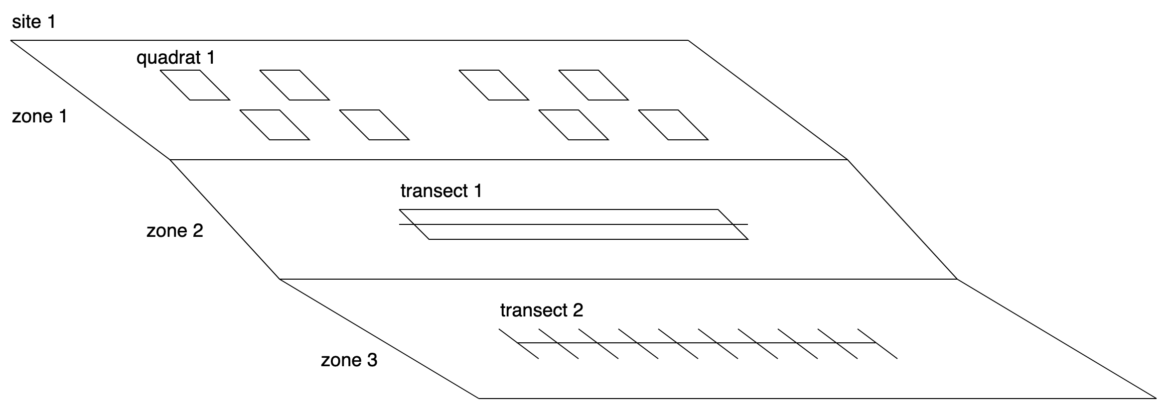
Figure: A fictional macroalgae survey with a single site, multiple zones, quadrats, and different types of transects.
Event core:
First we can create the Event core table by extracting all events in a broad sense and populating attributes such as time, location, and depth at the appropriate level. The events at the different levels are linked together using eventID and parentEventID. As the survey sites has a fixed location we can populate decimalLongitude and decimalLatitude at the top level event. The zones have different depths, so minimumDepthInMeters and maximumDepthInMeters are populated at the zone level. Finally, as not all sampling was done on the same day, eventDate is populated at the quadrat and transect level.
| eventID | parentEventID | eventDate | decimalLongitude | decimalLatitude | minimumDepthInMeters | maximumDepthInMeters |
|---|---|---|---|---|---|---|
| site_1 | 54.7943 | 16.9425 | ||||
| zone_1 | site_1 | 0 | 0 | |||
| zone_2 | site_1 | 0 | 5 | |||
| zone_3 | site_1 | 5 | 10 | |||
| quadrat_1 | zone_1 | 2019-01-02 | ||||
| transect_1 | zone_2 | 2019-01-03 | ||||
| transect_2 | zone_3 | 2019-01-04 |
Occurrence extension:
Next we can construct the Occurrence extension table. This table has the scientific names and links to the World Register of Marine Species in scientificNameID. The first column of the table references the events in the core table (see quadrat_1 for example highlighted in green).
| id | occurrenceID | scientificName | scientificNameID |
|---|---|---|---|
| quadrat_1 | occ_1 | Ulva rigida | urn:lsid:marinespecies.org:taxname:145990 |
| quadrat_1 | occ_2 | Ulva lactuca | urn:lsid:marinespecies.org:taxname:145984 |
| transect_1 | occ_3 | Plantae | urn:lsid:marinespecies.org:taxname:3 |
| transect_1 | occ_4 | Plantae | urn:lsid:marinespecies.org:taxname:3 |
| transect_2 | occ_5 | Gracilaria | urn:lsid:marinespecies.org:taxname:144188 |
| transect_2 | occ_6 | Laurencia | urn:lsid:marinespecies.org:taxname:143914 |
extendedMeasurementOrFact (eMoF) extension:
And finally there is the MeasurementOrFact extension table, which has attributes of the zones (shore height), the quadrats (surface area), the transects (surface area and length), and the occurrences (percentage cover and functional group). Attributes of occurrences point to the Occurrence extension table using the occurrenceID column (see occ_1 and occ_2 highlighted in blue and orange). Note that besides NERC vocabulary terms we are also referencing the CATAMI vocabulary for macroalgal functional groups.
| id | occurrenceID | measurementType | measurementTypeID | measurementValue | measurementValueID | measurementUnit | measurementUnitID |
|---|---|---|---|---|---|---|---|
| zone_1 | shore height | ? | high | ? | |||
| quadrat_1 | surface area | P01/current/AREABEDS | 0.25 | m2 | P06/current/UMSQ | ||
| quadrat_1 | occ_1 | cover | P01/current/SDBIOL10 | 24 | percent | P06/current/UPCT | |
| quadrat_1 | occ_2 | cover | P01/current/SDBIOL10 | 56 | percent | P06/current/UPCT | |
| transect_1 | surface area | P01/current/AREABEDS | 60 | m2 | P06/current/UMSQ | ||
| transect_1 | length | P01/current/LENTRACK | 30 | m | P06/current/ULAA | ||
| transect_1 | occ_3 | functional group | ? | sheet-like red | CATAMI:80300925 | ||
| transect_1 | occ_4 | functional group | ? | filamentous brown | CATAMI:80300931 | ||
| transect_1 | occ_3 | cover | P01/current/SDBIOL10 | 8 | percent | P06/current/UPCT | |
| transect_1 | occ_4 | cover | P01/current/SDBIOL10 | 24 | percent | P06/current/UPCT | |
| transect_2 | occ_5 | cover | P01/current/SDBIOL10 | 4 | percent | P06/current/UPCT | |
| transect_2 | occ_6 | cover | P01/current/SDBIOL10 | 16 | percent | P06/current/UPCT |
4.10.0.6 Marine birds abundance & distribution
The example for ENV-DATA collected with marine bird sightings/occurrences is based on the dataset “RV Investigator Voyage IN2017_V02 Seabird Observations, Australia (2017)”. In this dataset, seabird sightings were recorded continuously during daylight hours during a voyage to recover and redeploy moorings at the SOTS site, southwest of Tasmania, Australia, in March 2017. Observations were made from c.30 minutes before sunrise to c.30 minutes after sunset, extending to 300m in the forward quadrant with the best viewing conditions. There were 1200 observations from 38 species of birds along with 3 cetacean species and one seal. This example will focus on the ENV-DATA associated with the bird sightings. The most frequently sighted bird species were Puffinus tenuirostris (Short-tailed Shearwater) and Pachyptila turtur (Fairy Prion).
For this dataset, human observation recorded individual bird sightings (thus, each specimen is a single occurrence). The dataset contains abiotic measurements (ENV-DATA) which are related to each individual sighting, instead of an entire sample. Therefore, we can create an Occurrence core with an eMoF extension that contain the abiotic environmental measurements or facts.
Occurrence core:
The Occurrence core is populated with the occurrence records of seabirds sighted during the RV voyages. Occurrence details and scientific names are provided here. All birds were observed above sea level, all minimumDepthInMeters and maximumDepthInMeters values equal zero.
| occurrenceID | eventDate | institutionCode | collectionCode |
|---|---|---|---|
| in2017_v02_00998 | 2017-03-17 01:07:00 | Australasian Seabird Group, BirdLife Australia | in2017_v02_wov |
| in2017_v02_01380 | 2017-03-19 22:26:00 | Australasian Seabird Group, BirdLife Australia | in2017_v02_wov |
| in2017_v02_01012 | 2017-03-17 02:38:00 | Australasian Seabird Group, BirdLife Australia | in2017_v02_wov |
| basisOfRecord | recordedBy | organismQuantity | organismQuantityType | occurrenceStatus |
|---|---|---|---|---|
| HumanObservation | EJW+CRC+TAH | 2 | individuals | present |
| HumanObservation | EJW+CRC+TAH | 1 | individuals | present |
| HumanObservation | EJW+CRC+TAH | 1 | individuals | present |
| decimalLatitude | decimalLongitude | coordinateUncertaintyInMeters | coordinatePrecision | footprintWKT |
|---|---|---|---|---|
| -43.40741 | 147.45576 | 200 | 0.0018 | POINT (147.45576 -43.40741) |
| -45.98644 | 142.1445 | 200 | 0.0018 | POINT (142.14450 -45.98644) |
| -43.40728 | 147.45549 | 200 | 0.0018 | POINT (147.45549 -43.40728) |
| scientificNameID | scientificName | scientificNameAuthorship | vernacularName |
|---|---|---|---|
| urn:lsid:marinespecies.org:taxname:343991 | Morus serrator | (Gray,1843) | Australasian Gannet |
| urn:lsid:marinespecies.org:taxname:212648 | Pachyptila turtur | (Kuhl,1820) | Fairy Prion |
| urn:lsid:marinespecies.org:taxname:707545 | Chroicocephalus novaehollandiae | Stephens,1826 | Silver Gull |
extendedMeasurementOrFact (eMoF) extension:
As shown in previous examples, the MeasurementOrFact extension table contains abiotic measurements or facts corresponding to an occurrence / sighting. Individual sightings and abiotic measurements are linked with occurrenceID. In the example dataset, the ENV-DATA consist of measurements taken during the moorings deployment at the SOTS site, at the time of the marine bird sightings. In addition to NERC vocabulary terms, authors also referenced the Australian Ocean Data Network (AODN) Discovery Parameter Vocabulary for Sea-floor depth (m) and Sea Surface Temperature as measurementType. NERC equivalents to the AODN terms are added as additional MeasurementOrFact (MoF) records.
| occurrenceID | measurementID | measurementType | measurementTypeID |
|---|---|---|---|
| in2017_v02_00998 | in2017_v02_00998-depth | Sea-floor depth (m) | http://vocab.aodn.org.au/def/discovery_parameter/entity/574 |
| in2017_v02_00998 | in2017_v02_00998-depth | Sea-floor depth | http://vocab.nerc.ac.uk/collection/P01/current/MBANZZZZ/ |
| in2017_v02_00998 | in2017_v02_00998-air_pressure | Air Pressure (hPa) | http://vocab.nerc.ac.uk/collection/P01/current/CAPHZZ01 |
| in2017_v02_00998 | in2017_v02_00998-air_temp | Atmospheric temperature (deg C) | http://vocab.nerc.ac.uk/collection/P01/current/CTMPZZ01 |
| in2017_v02_00998 | in2017_v02_00998-wov_sea_state | Sea state | http://vocab.nerc.ac.uk/collection/C39/current/ |
| in2017_v02_00998 | in2017_v02_00998-sea_surface_temp | Sea surface temperature | http://vocab.aodn.org.au/def/discovery_parameter/entity/97 |
| in2017_v02_00998 | in2017_v02_00998-sea_surface_temp | Sea surface temperature | http://vocab.nerc.ac.uk/standard_name/sea_surface_temperature/ |
| in2017_v02_00998 | in2017_v02_00998-wind_direction | Wind direction (deg) | http://vocab.nerc.ac.uk/collection/P01/current/EWDAZZ01 |
| in2017_v02_00998 | in2017_v02_00998-wind_speed | Wind Speed (knt) | http://vocab.nerc.ac.uk/collection/P01/current/ESSAZZ01 |
| measurementValue | measurementValueID | measurementUnit | measurementUnitID |
|---|---|---|---|
| 73.0313 | NA | Metres | http://vocab.nerc.ac.uk/collection/P06/current/ULAA |
| 73.0313 | NA | Metres | http://vocab.nerc.ac.uk/collection/P06/current/ULAA |
| 1024.91385 | NA | hPa | http://vocab.nerc.ac.uk/collection/P06/current/HPAX |
| 15.3 | NA | degrees Celsius | http://vocab.nerc.ac.uk/collection/P06/current/UPAA |
| moderate 1.25 - 2.5 m | http://vocab.nerc.ac.uk/collection/C39/current/4/ | ||
| 17.32 | NA | degrees Celsius | http://vocab.nerc.ac.uk/collection/P06/current/UPAA |
| 17.32 | NA | degrees Celsius | http://vocab.nerc.ac.uk/collection/P06/current/UPAA |
| 283 | NA | degrees | http://vocab.nerc.ac.uk/collection/P06/current/UABB |
| 5.49 | NA | Knots (nautical miles per hour) | http://vocab.nerc.ac.uk/collection/P06/current/UKNT |
4.10.0.7 Marine mammals abundance & distribution
In this section we will explore how to encode a survey data set into Darwin Core using the ENV-DATA approach. As an example, sections of the actual data set of CETUS: Cetacean monitoring surveys in the Eastern North Atlantic, is used.
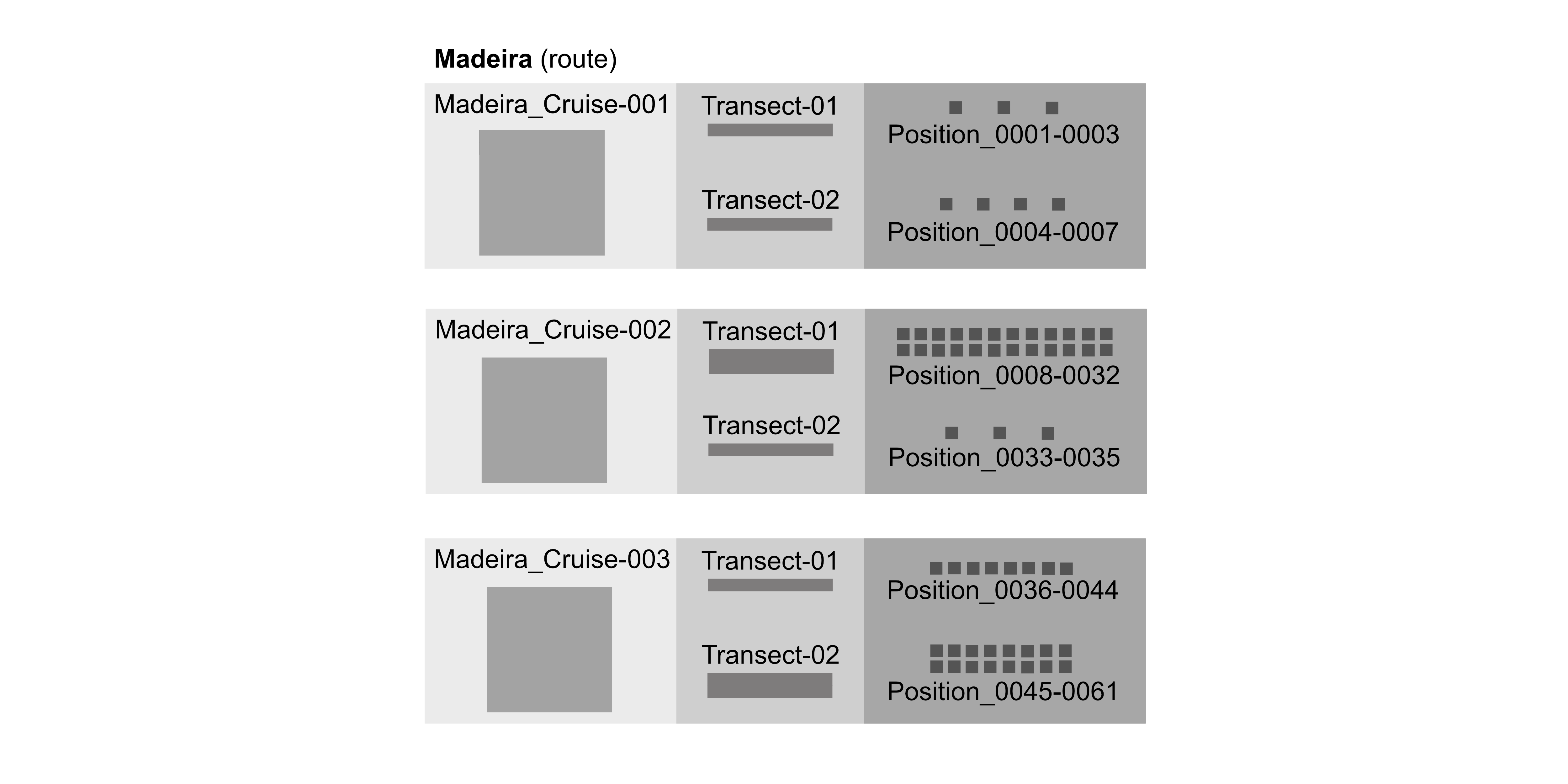 Figure: A representation of the observation events of CETUS: Cetacean monitoring surveys in the Eastern North Atlantic, presenting the route Madeira as a site with three cruises (zones). Each Cruise is divided into different Transects and each transect contains a number of Positions.
Event core:
Create the Event core table by extracting all events and populating attributes. As in the previous example, the events at the different levels are linked together using eventID and parentEventID. As the survey observations were made at locations of cetacean sightings instead of fixed locations, we can populate footprintWKT and footprintSRS as location information. Not all sampling was done on the same day, therefore eventDate is populated at the transect level.
| eventID | parentEventID | eventDate | footprintWKT | footprintSRS |
|---|---|---|---|---|
| Madeira | 2012-07/2017-09 | POLYGON ((-16.74 31.49, -16.74 41.23, -8.70 41.23, -8.70 31.49, -16.74 31.49)) | EPSG:4326 | |
| Madeira:Cruise-001 | Madeira | 2012-07 | MULTIPOINT ( (-8.7 41.19), (-9.15 38.7)) | EPSG:4326 |
| Madeira:Cruise-002 | Madeira | 2012-07 | MULTIPOINT ( (-9.15 38.7), (-16.73 32.74)) | EPSG:4326 |
| Madeira:Cruise-003 | Madeira | 2012-07 | MULTIPOINT ( (-16.73 32.74), (-9.15 38.7)) | EPSG:4326 |
Occurrence extension:
Construct the Occurrence extension table with the scientific names and links to the World Register of Marine Species in scientificNameID. The first column of the table references the events in the core table (see Madeira:Cruise-001 highlighted in green).The occurrenceID corresponds to the Position of the observation (see Transect-01:Pos-0001 and CIIMAR-CETUS-0001 highlighted in blue, or Transect-01:Pos-0002 and CIIMAR-CETUS-0002 highlighted in orange).
| id | occurrenceID | scientificNameID | scientificName |
|---|---|---|---|
| Madeira:Cruise-001:Transect-01:Pos-0001 | CIIMAR-CETUS-0001 | urn:lsid:marinespecies.org:taxname:2688 | Cetacea |
| Madeira:Cruise-001:Transect-01:Pos-0002 | CIIMAR-CETUS-0002 | urn:lsid:marinespecies.org:taxname:2688 | Cetacea |
| Madeira:Cruise-001:Transect-01:Pos-0003 | CIIMAR-CETUS-0003 | urn:lsid:marinespecies.org:taxname:2688 | Cetacea |
| Madeira:Cruise-001:Transect-02:Pos-0004 | CIIMAR-CETUS-0004 | urn:lsid:marinespecies.org:taxname:2688 | Cetacea |
| Madeira:Cruise-001:Transect-02:Pos-0005 | CIIMAR-CETUS-0005 | urn:lsid:marinespecies.org:taxname:2688 | Cetacea |
| Madeira:Cruise-001:Transect-02:Pos-0006 | CIIMAR-CETUS-0006 | urn:lsid:marinespecies.org:taxname:2688 | Cetacea |
| Madeira:Cruise-001:Transect-02:Pos-0007 | CIIMAR-CETUS-0007 | urn:lsid:marinespecies.org:taxname:2688 | Cetacea |
extendedMeasurementOrFact (eMoF) extension:
And finally, the extendedMeasurementOrFact extension table has attributes of the zones (such as Vessel speed and Vessel Heading), the Transects (such as Wave height and Wind speed), and the Positions (such as Visibility and the Number of smaal/big ships >20m). Attributes of Positions point to the Occurrence extension table using the occurrenceID column (see Transect-01:Pos-0001 and Transect-01:Pos-0002 highlighted in blue and orange, respectively).
| id | occurrenceID | measurementType | measurementTypeID | measurementValue | measurementUnit | measurementUnitID |
|---|---|---|---|---|---|---|
| Madeira:Cruise-001 | Vessel name | Q01/current/Q0100001 | Monte da Guia | |||
| Madeira:Cruise-001:Transect-01 | Length of the track | P01/current/DSRNCV01 | 39.75 | km | P06/current/ULKM | |
| Madeira:Cruise-001:Transect-01:Pos-0001 | CIIMAR-CETUS-0001 | Visibility | 2000-4000 | Meters | P06/current/ULAA | |
| Madeira:Cruise-001:Transect-01:Pos-0001 | CIIMAR-CETUS-0001 | Wind speed | P01/current/WMOCWFBF | 1 | Beaufort scale | |
| Madeira:Cruise-001:Transect-01:Pos-0001 | CIIMAR-CETUS-0001 | Wave height | 2 | Douglas scale | ||
| Madeira:Cruise-001:Transect-01:Pos-0001 | CIIMAR-CETUS-0001 | Number of big ships (>20m) | 3 | |||
| Madeira:Cruise-001:Transect-01:Pos-0001 | CIIMAR-CETUS-0001 | Vessel heading | P01/current/HDNGGP01 | 206 | Degrees | P06/current/UAAA |
| Madeira:Cruise-001:Transect-01:Pos-0001 | CIIMAR-CETUS-0001 | Number of small ships (<20m) | 0 | |||
| Madeira:Cruise-001:Transect-01:Pos-0001 | CIIMAR-CETUS-0001 | Vessel speed | P01/current/APSAGP01 | 16 | Knots (nautical miles per hour) | P06/current/UKNT |
4.10.0.8 Marine turtles abundance & distribution
4.10.0.8.1 Survey & sighting data
This section deals with encoding survey and/ or sighting data of sea turtles into Darwin Core using the ENV-DATA approach. Extracts from the actual data set of Presence of sea turtles collected through Fixed-Line-Transect monitoring across the Western Mediterranean Sea (Civitavecchia-Barcelona route) between 2013 and 2017, are used as an example.
Event core:
The Event core is created by extracting all sighting events and populating the attributes at each event. The events at the different levels are linked together using eventID and parentEventID. In the example dataset, turtle sightings have been recorded since 2007, along a ferry route between Italy and Spain, as part of the monitoring project FLT Med Net (Fixed Line Transect Mediterranean monitoring Network). Turtle sighting locations can be given by populating the fields footprintWKT and footprintSRS with location information. Sightings were recorded at different dates, therefore eventDate is populated at the transect level.
| id | modified | datasetID | datasetName |
|---|---|---|---|
| TURTLE_CBAR_0043 | 2021-05-05 07:59:08 | https://marineinfo.org/id/dataset/6403 | Presence of sea turtles collected through Fixed-Line-Transect monitoring across the Western Mediterranean Sea |
| TURTLE_CBAR_0045 | 2021-05-05 07:59:08 | https://marineinfo.org/id/dataset/6403 | Presence of sea turtles collected through Fixed-Line-Transect monitoring across the Western Mediterranean Sea |
| TURTLE_CBAR_0045_0001 | 2021-05-05 07:59:08 | https://marineinfo.org/id/dataset/6403 | Presence of sea turtles collected through Fixed-Line-Transect monitoring across the Western Mediterranean Sea |
| TURTLE_CBAR_0045_0002 | 2021-05-05 07:59:08 | https://marineinfo.org/id/dataset/6403 | Presence of sea turtles collected through Fixed-Line-Transect monitoring across the Western Mediterranean Sea |
| eventID | parentEventID | eventDate |
|---|---|---|
| TURTLE_CBAR_0043 | 2013-04-03T05:30:00+02:00/2013-04-03T16:00:00+02:00 | |
| TURTLE_CBAR_0045 | 2013-04-18T05:22:00+02:00/2013-04-18T15:53:00+02:00 | |
| TURTLE_CBAR_0045_0001 | TURTLE_CBAR_0045 | 2013-04-18T05:55:00+02:00 |
| TURTLE_CBAR_0045_0002 | TURTLE_CBAR_0045 | 2013-04-18T08:35:00+02:00 |
| eventRemarks | minimumDepthInMeters | maximumDepthInMeters | decimalLatitude | decimalLongitude |
|---|---|---|---|---|
| transect | 0 | 0 | 41.26179967 | 4.933265167 |
| transect | 0 | 0 | 41.30371367 | 4.936571167 |
| sample | 0 | 0 | 41.3228 | 7.4984 |
| sample | 0 | 0 | 41.322845 | 5.995345 |
| geodeticDatum | coordinateUncertaintyInMeters | footprintWKT | footprintSRS |
|---|---|---|---|
| EPSG:4326 | 222970.2874 | LINESTRING (7.602633333333 41.24378333333, 2.263897 41.279816) | EPSG:4326 |
| EPSG:4326 | 225420.0359 | LINESTRING (7.636983333333 41.32418333333, 2.236159 41.283244) | EPSG:4326 |
| EPSG:4326 | POINT | EPSG:4326 | |
| EPSG:4326 | POINT | EPSG:4326 |
Occurrence extension:
The Occurrence extension contain details regarding the sighted animals and include scientificName and the links to the World Register of Marine Species in scientificNameID. The EventID references the events as in the Event core. This table further provides information on the basisOfRecord and occurrenceStatus.
| EventID | occurrenceID | datasetID | collectionCode | basisOfRecord |
|---|---|---|---|---|
| TURTLE_CBAR_0043 | AdL_TURTLE_CBAR_0001 | https://marineinfo.org/id/dataset/6403 | TURTLE_CBAR_13-17 | HumanObservation |
| TURTLE_CBAR_0045 | AdL_TURTLE_CBAR_0004 | https://marineinfo.org/id/dataset/6403 | TURTLE_CBAR_13-17 | HumanObservation |
| TURTLE_CBAR_0045_0001 | AdL_TURTLE_CBAR_0005 | https://marineinfo.org/id/dataset/6403 | TURTLE_CBAR_13-17 | HumanObservation |
| TURTLE_CBAR_0045_0002 | AdL_TURTLE_CBAR_0006 | https://marineinfo.org/id/dataset/6403 | TURTLE_CBAR_13-17 | HumanObservation |
| catalogNumber | recordedBy | occurrenceStatus |
|---|---|---|
| AdL_TURTLE_CBAR_0001 | Ilaria Campana | Miriam Paraboschi | Erica Ercoli | Erica | absent |
| AdL_TURTLE_CBAR_0004 | Antonella Arcangeli | Cristina Berardi | Lucilla Giulietti | Claudia Boccardi | absent |
| AdL_TURTLE_CBAR_0005 | Antonella Arcangeli | Cristina Berardi | Lucilla Giulietti | Claudia Boccardi | present |
| AdL_TURTLE_CBAR_0006 | Antonella Arcangeli | Cristina Berardi | Lucilla Giulietti | Claudia Boccardi | present |
| scientificNameID | scientificName | kingdom | scientificNameAuthorship |
|---|---|---|---|
| urn:lsid:marinespecies.org:taxname:136999 | Cheloniidae | Animalia | Oppel, 1811 |
| urn:lsid:marinespecies.org:taxname:136999 | Cheloniidae | Animalia | Oppel, 1811 |
| urn:lsid:marinespecies.org:taxname:137205 | Caretta caretta | Animalia | Linnaeus, 1758 |
| urn:lsid:marinespecies.org:taxname:137205 | Caretta caretta | Animalia | Linnaeus, 1758 |
extendedMeasurementOrFact (eMoF) extension:
The extendedMeasurementOrFact extension (eMoF) for survey or sighting data contains additional attributes and measurements recorded during the survey, such as those regarding the Research Vessel, environmental conditions, and/ or animal measurements. These attributes are linked to the Occurrence extension using the occurrenceID. The example dataset contain measurements regarding the sampling method; speed and height of the Research Vessel as platform; wind force; sighting distance; as well as the count and developmental stage of the biological entity.
| id | occurrenceID | measurementType | measurementTypeID |
|---|---|---|---|
| TURTLE_CBAR_0045 | AdL_TURTLE_CBAR_0004 | BEAUFORT WIND FORCE | http://vocab.nerc.ac.uk/collection/P01/current/WMOCWFBF |
| TURTLE_CBAR_0045 | AdL_TURTLE_CBAR_0004 | Platform height | http://vocab.nerc.ac.uk/collection/P01/current/AHSLZZ01 |
| TURTLE_CBAR_0045 | AdL_TURTLE_CBAR_0004 | Sampling method | http://vocab.nerc.ac.uk/collection/Q01/current/Q0100003 |
| TURTLE_CBAR_0045 | AdL_TURTLE_CBAR_0004 | Speed of measurement platform relative to ground surface {speed over ground} by unspecified GPS system | http://vocab.nerc.ac.uk/collection/P01/current/APSAGP01 |
| TURTLE_CBAR_0045_0001 | AdL_TURTLE_CBAR_0005 | Development stage of biological entity specified elsewhere | http://vocab.nerc.ac.uk/collection/P01/current/LSTAGE01 |
| TURTLE_CBAR_0045_0001 | AdL_TURTLE_CBAR_0005 | Count (in assayed sample) of biological entity specified elsewhere | http://vocab.nerc.ac.uk/collection/P01/current/OCOUNT01 |
| TURTLE_CBAR_0045_0001 | AdL_TURTLE_CBAR_0005 | Sighting distance |
| measurementValue | measurementUnit | measurementUnitID |
|---|---|---|
| 0 | Beaufort scale | |
| 29 | Metres | http://vocab.nerc.ac.uk/collection/P06/current/ULAA/ |
| visual observation from ferries | ||
| 23.291 | Knots (nautical miles per hour) | http://vocab.nerc.ac.uk/collection/P06/current/UKNT/ |
| 1 | ||
| 20 | Metres | http://vocab.nerc.ac.uk/collection/P06/current/ULAA/ |
In addition to the measurements recorded by the example dataset, other measurements are also possible depending on the scope and aims of the survey project. The example dataset Incidental sea snake and turtle bycatch records from the RV Southern Surveyor voyage SS199510, Gulf of Carpentaria, Australia (Nov 1995) for example, contain information regarding the length and weight of the biological entity as follows:
extendedMeasurementOrFact (eMoF) extension:
| id | measurementID | occurrenceID | measurementType | measurementTypeID | measurementValue | measurementUnit | measurementUnitID |
|---|---|---|---|---|---|---|---|
| SS199510-001 | SS199510-001-length | SS199510-001 | Length | http://vocab.nerc.ac.uk/collection/P01/current/OBSINDLX | 1250 | Millimetres | http://vocab.nerc.ac.uk/collection/P06/current/UXMM |
| SS199510-001 | SS199510-001-weight | SS199510-001 | Weight | http://vocab.nerc.ac.uk/collection/P01/current/SPWGXX01 | 800 | Grams | http://vocab.nerc.ac.uk/collection/P06/current/UGRM |
| SS199510-002 | SS199510-002-length | SS199510-002 | Length | http://vocab.nerc.ac.uk/collection/P01/current/OBSINDLX | 1630 | Millimetres | http://vocab.nerc.ac.uk/collection/P06/current/UXMM |
| SS199510-002 | SS199510-002-weight | SS199510-002 | Weight | http://vocab.nerc.ac.uk/collection/P01/current/SPWGXX01 | 1477.7 | Grams | http://vocab.nerc.ac.uk/collection/P06/current/UGRM |
4.10.0.10 Phytoplankton biomass & diversity
This example deals with encoding phytoplankton observation data, including environmental data, into Darwin Core. Extracts from the actual data set LifeWatch observatory data: phytoplankton observations by imaging flow cytometry (FlowCam) in the Belgian Part of the North Sea, are used as an example.
Event core:
The Event core contains events at the different levels and are linked together with eventID and parentEventID. In this example,the dataset contains records pointing to the origin, the in-situ sampling position as well as a record referring to the ex-situ collection of living specimens. In this case, the the event type information is provided in type. The recommended practice for providing the countryCode is to use an ISO 3166-1-alpha-2 country code. If additional information regarding licencing is provided, these can be populated under rightsHolder and accessRights. The remaining Event core fields provide location data including datasetID and datasetName, locationID, waterBody, maximumDepthInMeters, minimumDepthInMeters, decimalLongitude, decimalLatitude, coordinateUncertaintyInMeters, geodeticDatum and footprintSRS.
| eventID | parentEventID | eventRemarks | eventDate | modified |
|---|---|---|---|---|
| TripNR3242 | cruise | 2017-05T13:18:00+00:00/2017-05T22:14:00+00:00 | 2021-10-21 15:52:00 | |
| TripNR3242TripStationNR16781 | TripNR3242 | stationVisit | 2017-05-08T20:44:00+00:00/2017-05-08T20:55:00+00:00 | 2021-10-21 15:52:00 |
| TripNR3242TripStationNR16781MidasTripActionID105598 | TripNR3242TripStationNR16781 | sample | 2017-05-08T20:50:00+00:00 | 2021-10-21 15:52:00 |
| TripNR3242TripStationNR16781MidasTripActionID105598UW | TripNR3242TripStationNR16781 | sample | 2017-05-08T20:50:00+00:00 | 2021-10-21 15:52:00 |
| datasetID | datasetName | locationID | waterBody | country | countryCode |
|---|---|---|---|---|---|
| https://marineinfo.org/id/dataset/4688 | LifeWatch observatory data: phytoplankton observations… | North Sea | Belgium | BE | |
| https://marineinfo.org/id/dataset/4688 | JN17_5 | ||||
| https://marineinfo.org/id/dataset/4688 | JN17_5 | ||||
| https://marineinfo.org/id/dataset/4688 | JN17_5 |
| minimumDepthInMeters | maximumDepthInMeters | decimalLatitude | decimalLongitude | geodeticDatum | coordinateUncertaintyInMeters | footprintSRS |
|---|---|---|---|---|---|---|
| EPSG:4326 | EPSG:4326 | |||||
| 0 | 30.22 | 51.0131 | 1.90562 | EPSG:4326 | 1.11 | EPSG:4326 |
| 0 | 1 | 51.01203 | 1.90217 | EPSG:4326 | 1.11 | EPSG:4326 |
| 3 | 3 | 51.01203 | 1.90217 | EPSG:4326 | 1.11 | EPSG:4326 |
Occurrence extension:
The Occurrence extension contains data of each occurrence with an occurrenceID and is linked to the Event core with the eventID. The Occurrence extension should provide information on the basisOfRecord and occurrenceStatus. Scientific names and links to the World Register of Marine Species should be provided under scientificName and scientificNameID, respectively.
| eventID | occurrenceID |
|---|---|
| TripNR3242TripStationNR16781MidasTripActionID105598 | TripNR3242TripStationNR16781MidasTripActionID105598occurenceIDTA_105598_(Pseudo-)pediastrum_5 |
| TripNR3242TripStationNR16781MidasTripActionID105598 | TripNR3242TripStationNR16781MidasTripActionID105598occurenceIDTA_105598_Actinoptychus senarius_5 |
| TripNR3242TripStationNR16781MidasTripActionID105598 | TripNR3242TripStationNR16781MidasTripActionID105598occurenceIDTA_105598_Actinoptychus splendens_5 |
| TripNR3242TripStationNR16781MidasTripActionID105598 | TripNR3242TripStationNR16781MidasTripActionID105598occurenceIDTA_105598_Actinoptychus_5 |
| modified | basisOfRecord | occurrenceStatus | scientificNameID | scientificName |
|---|---|---|---|---|
| 2021-10-21 | Occurrence | absent | urn:lsid:marinespecies.org:taxname:160560 | Hydrodictyaceae |
| 2021-10-21 | Occurrence | present | urn:lsid:marinespecies.org:taxname:148948 | Actinoptychus senarius |
| 2021-10-21 | Occurrence | present | urn:lsid:marinespecies.org:taxname:148949 | Actinoptychus splendens |
| 2021-10-21 | Occurrence | present | urn:lsid:marinespecies.org:taxname:148947 | Actinoptychus |
extendedMeasurementOrFact (eMoF) extension:
The eMoF extension contains the environmental and measurement information and data of each occurrence. This extension is also linked to the Event core using the eventID, and linked to the Occurrence extension table using the occurrenceID. The various measurements are populated with measurementID, measurementType, measurementTypeID, measurementUnit, measurementUnitID, measurementValue, measurementValueID, measurementAccuracy, measurementMethod, measurementDeterminedBy and measurementDeterminedDate. In the example dataset,the LifeWatch observatory data was compiled using imaging flow cytometry (FlowCam) to observe and identify phytoplankton in the Belgian Part of the North Sea and recorded a number of measurements including abundance, lifestages, sampling device information as well as environmental measurements such as water temperature, salinity and conductivity with accompanying vocabulary.
| id | occurrenceID | measurementType |
|---|---|---|
| TripNR3242 | Platform Name | |
| TripNR3242TripStationNR16781MidasTripActionID105598 | TripNR3242TripStationNR16781MidasTripActionID105598occurenceIDTA_105598_Actinoptychus_5 | Abundance of Actinoptychus (WoRMS:148947) per unit volume of the water body by image analysis |
| TripNR3242TripStationNR16781MidasTripActionID105598 | TripNR3242TripStationNR16781MidasTripActionID105598occurenceIDTA_105598_Actinoptychus senarius_5 | Abundance of Actinoptychus senarius (WoRMS:148948) per unit volume of the water body by image analysis |
| TripNR3242TripStationNR16781MidasTripActionID105598 | TripNR3242TripStationNR16781MidasTripActionID105598occurenceIDTA_105598_(Pseudo-)pediastrum_5 | Lifestage |
| TripNR3242TripStationNR16781MidasTripActionID105598 | TripNR3242TripStationNR16781MidasTripActionID105598occurenceIDTA_105598_Actinoptychus senarius_5 | Lifestage |
| TripNR3242TripStationNR16781MidasTripActionID105598 | Sampling device aperture diameter | |
| TripNR3242TripStationNR16781MidasTripActionID105598 | Sampling instrument name | |
| TripNR3242TripStationNR16781MidasTripActionID105598 | Sampling net mesh size | |
| TripNR3242TripStationNR16781MidasTripActionID105598UW | Conductivity of the water body | |
| TripNR3242TripStationNR16781MidasTripActionID105598UW | Practical salinity of the water body | |
| TripNR3242TripStationNR16781MidasTripActionID105598UW | Temperature of the water body |
| measurementUnitID | measurementDeterminedBy | measurementMethod |
|---|---|---|
| Flanders Marine Institute | ||
| http://vocab.nerc.ac.uk/collection/P06/current/UCPL | Flanders Marine Institute | identified and counted by image analysis and normalised to a unit volume of water body, validated by human |
| http://vocab.nerc.ac.uk/collection/P06/current/UCPL | Flanders Marine Institute | identified and counted by image analysis and normalised to a unit volume of water body, validated by human |
| Flanders Marine Institute | identified and counted by image analysis and normalised to a unit volume of water body, validated by human | |
| Flanders Marine Institute | identified and counted by image analysis and normalised to a unit volume of water body, validated by human | |
| http://vocab.nerc.ac.uk/collection/P06/current/ULAA/ | Flanders Marine Institute | |
| Flanders Marine Institute | ||
| http://vocab.nerc.ac.uk/collection/P06/current/UMIC/ | Flanders Marine Institute | |
| http://vocab.nerc.ac.uk/collection/P06/current/UECA | Flanders Marine Institute | Electrical conductivity of the water body by thermosalinograph, based on the UnderWaySystem of the ship |
| http://vocab.nerc.ac.uk/collection/P06/current/UGKG/ | Flanders Marine Institute | Practical salinity of the water body based on water from the UnderWaySystem of the ship |
| http://vocab.nerc.ac.uk/collection/P06/current/UPAA/ | Flanders Marine Institute | Temperature of the water body based on water from the UnderWaySystem of the ship |
4.10.0.11 Seagrass cover & composition
The structure of the Event, Occurrence and extendedMeasurementOrFact extensions for Seagrass Cover & Composition is based on community feedback organised through the the Scientific Committee on Oceanic Research (SCOR): Coordinated Global Research Assessment of Seagrass System (C-GRASS). We acknowledge the work that the C-grass SCOR work group has done to develop a proposed scheme for completing Seagrass related extension files.
Here encode seagrass survey data into Darwin Core according to the ENV-DATA approach and using sections of the actual data set of Seagrass Monitoring at Chengue Bay, Colombia as an example dataset.
Event core:
The Event core table is created by extracting all events and attributes. All events are linked together using eventID and parentEventID. eventDate is populated at the transect level with the recommended format that conforms to ISO 8601-1:2019. habitat is populated as a category or description of the habitat in which the event occurred. Additional fieldNotes can also be provided if applicable. The recommended best practice for countryCode is to use an ISO 3166-1-alpha-2 country code. The remaining Event core fields comprise of location data including maximumDepthInMeters, minimumDepthInMeters, decimalLongitude, decimalLatitude, coordinateUncertaintyInMeters, footprintWKT and footprintSRS. Addtionally in the Event core, it is recommended to further include information regarding license, rightsHolder, bibliographicCitation, institutionID, datasetID, institutionCode and datasetName.
| eventID | parentEventID | eventDate | habitat | fieldNotes | countryCode |
|---|---|---|---|---|---|
| USBsg-chengue-pastocoral | 2019-05-13 | seagrass | no notes | CO | |
| USBsg-chengue-pastomanglar | 2019-05-14 | seagrass | no notes | CO | |
| USBsg-chengue-pastocoral-SquidPopTransect1 | USBsg-chengue-pastocoral | 2019-05-13 | seagrass | no notes | CO |
| USBsg-chengue-pastocoral-SquidPopTransect2 | USBsg-chengue-pastocoral | 2019-05-13 | seagrass | no notes | CO |
| minimumDepthInMeters | maximumDepthInMeters | decimalLatitude | decimalLongitude | coordinateUncertaintyInMeters | footprintWKT | footprintSRS |
|---|---|---|---|---|---|---|
| 0.8 | 2 | 11.32021806 | -74.12753684 | 10 | POLYGON ((-74.1273259763024 11.320475512862,-74.1272978004008 11.3201655779439)) | EPSG:4326 |
| 0.8 | 0.8 | 11.31977189 | -74.12536879 | 10 | POLYGON ((-74.1253370891273 11.3195001294432,-74.1253337743154 11.3194968146313)) | EPSG:4326 |
| 0.8 | 2 | 11.32039927 | -74.12737404 | 50 | POINT (-74.1273740410759 11.3203992721869) | EPSG:4326 |
| 0.8 | 2 | 11.32027662 | -74.1273989 | 50 | POINT (-74.1273989021655 11.3202766241445) | EPSG:4326 |
Occurrence extension:
The Occurrence extension table contain data for each occurrence with an occurrenceID and is linked to the Event core with the eventID. This table should provide information on the basisOfRecord and occurrenceStatus. Scientific names and links to the World Register of Marine Species should be provided under scientificName and scientificNameID, respectively. If a species was identified by an expert, the field identifiedBy can be populated. If the species is well-known by another common name, this name can be provided under vernacularName.
| eventID | occurrenceID | basisOfRecord | occurrenceStatus | scientificNameID | scientificName |
|---|---|---|---|---|---|
| USBsg-chengue-pastocoral | USBsg-chengue-pastocoral-tt | HumanObservation | present | urn:lsid:marinespecies.org:taxname:374720 | Thalassia testudinum |
| USBsg-chengue-pastomanglar | USBsg-chengue-manglar-tt | HumanObservation | present | urn:lsid:marinespecies.org:taxname:374720 | Thalassia testudinum |
| USBsg-chengue-pastocoral-SquidPopTransect1 | USBsg-chengue-pastocoral-fish-001 | HumanObservation | present | urn:lsid:marinespecies.org:taxname:158815 | Halichoeres bivittatus |
| USBsg-chengue-pastocoral-SquidPopTransect1 | USBsg-chengue-pastocoral-fish-002 | HumanObservation | present | urn:lsid:marinespecies.org:taxname:158932 | Lactophrys triqueter |
extendedMeasurementOrFact (eMoF) extension:
The eMoF table contains the measurement information and data of each occurrence. This extension is also linked to the Event core using the eventID, and linked to the Occurrence table using the occurrenceID. The various measurements are populated with measurementType, measurementTypeID, measurementUnit, measurementUnitID, measurementValue, measurementValueID, measurementAccuracy, measurementMethod, measurementDeterminedBy and measurementDeterminedDate. The example dataset of Seagrass Monitoring at Chengue Bay, Colombia recorded a number of measurements and can be used as an example of how to populate the respective fields:
| eventID | occurrenceID | measurementID | measurementType |
|---|---|---|---|
| USBsg-chengue-pastocoral | USBsg-chengue-pastocoral-tt | USBsg-chengue-pastocoral-PhyQ01 | WaterTemp |
| USBsg-chengue-pastocoral | USBsg-chengue-pastocoral-tt | USBsg-chengue-pastocoral-PhyQ02 | Salinity |
| USBsg-chengue-pastocoral | USBsg-chengue-pastocoral-tt | USBsg-chengue-pastocoral-PhyQ03 | Dissolved oxygen |
| USBsg-chengue-pastocoral | USBsg-chengue-pastocoral-tt | USBsg-chengue-pastocoral-T1C1-shoot-01 | Shoot Density |
| USBsg-chengue-pastocoral | USBsg-chengue-pastocoral-tt | USBsg-chengue-pastocoral-T1C1-leafLenght-01 | Leaf Length |
| USBsg-chengue-pastocoral | USBsg-chengue-pastocoral-tt | USBsg-chengue-pastocoral-T1N1-DryBiomass | Total Dry Biomass |
| USBsg-chengue-pastocoral | USBsg-chengue-pastocoral-tt | USBsg-chengue-pastocoral-T1N1-biomassGL | Dry biomass of green leaves |
| USBsg-chengue-pastocoral | USBsg-chengue-pastocoral-tt | USBsg-chengue-pastocoral-T1N1-biomassNGL | Dry biomass of non green leaves |
| USBsg-chengue-pastocoral | USBsg-chengue-pastocoral-tt | USBsg-chengue-pastocoral-T1N1-biomassSH | Dry biomass of the shoots |
| USBsg-chengue-pastocoral | USBsg-chengue-pastocoral-tt | USBsg-chengue-pastocoral-T1N2-biomassR | Dry biomass of the roots |
| USBsg-chengue-pastocoral | USBsg-chengue-pastocoral-tt | USBsg-chengue-pastocoral-T1N2-biomassRIZ | Dry biomass of the rizome |
| USBsg-chengue-pastocoral | USBsg-chengue-pastocoral-tt | USBsg-chengue-pastocoral-T1N2-biomassOTH | Dry biomass of other seagrass species |
4.10.0.12 Zooplankton biomass & diversity
Here we will encode zooplankton observation and environmental data into Darwin Core. Extracts from the actual dataset LifeWatch observatory data: zooplankton observations by imaging (ZooScan) in the Belgian Part of the North Sea, are used as an example.
Event core:
The Event core contains events at the different levels and are linked together with eventID and parentEventID. In this example,the dataset contains records pointing to the origin, the in-situ sampling position as well as a record referring to the ex-situ collection of living specimens. In this case, the the event type information is provided in type. The recommended practice for providing the countryCode is to use an ISO 3166-1-alpha-2 country code. If additional information regarding licencing is provided, these can be populated under rightsHolder and accessRights. The remaining Event core fields provide location data including datasetID and datasetName, locationID, waterBody, maximumDepthInMeters, minimumDepthInMeters, decimalLongitude, decimalLatitude, coordinateUncertaintyInMeters, geodeticDatum and footprintSRS.
| eventID | parentEventID | eventRemarks | eventDate | modified |
|---|---|---|---|---|
| TripNR2547 | cruise | 2013-07-22T06:58:00+00:00/2013-07-22T16:58:00+00:00 | 2021-06-23 14:54:00 | |
| TripNR2547TripStationNR9781 | TripNR2547 | stationVisit | 2013-07-22T07:13:00+00:00/2013-07-22T07:26:00+00:00 | 2021-06-23 14:54:00 |
| TripNR2547TripStationNR9781MidasTripActionID23024 | TripNR2547TripStationNR9781 | sample | 2013-07-22T07:22:00+00:00 | 2021-06-23 14:54:00 |
| TripNR2547TripStationNR9781MidasTripActionID23024UW | TripNR2547TripStationNR9781 | sample | 2013-07-22T07:22:00+00:00 | 2021-06-23 14:54:00 |
| datasetID | datasetName | locationID | waterBody | country |
|---|---|---|---|---|
| https://marineinfo.org/id/dataset/4687 | LifeWatch observatory data: zooplankton observations… | Belgian Part of the North Sea | Belgium | |
| https://marineinfo.org/id/dataset/4687 | LifeWatch observatory data: zooplankton observations… | 130 | ||
| https://marineinfo.org/id/dataset/4687 | LifeWatch observatory data: zooplankton observations… | 130 | ||
| https://marineinfo.org/id/dataset/4687 | LifeWatch observatory data: zooplankton observations… | 130 |
| minimumDepthInMeters | maximumDepthInMeters | decimalLatitude | decimalLongitude | geodeticDatum | footprintSRS |
|---|---|---|---|---|---|
| EPSG:4326 | EPSG:4326 | ||||
| 0 | 13.4 | 51.27083333 | 2.905 | EPSG:4326 | EPSG:4326 |
| 0 | 0 | 51.2687318 | 2.901797 | EPSG:4326 | EPSG:4326 |
| 3 | 3 | 51.2687318 | 2.901797 | EPSG:4326 | EPSG:4326 |
Occurrence extension:
The Occurrence extension contains data of each occurrence with an occurrenceID and is linked to the Event core with the eventID. The Occurrence extension should provide information on the basisOfRecord and occurrenceStatus. Scientific names and links to the World Register of Marine Species should be provided under scientificName and scientificNameID, respectively.
| eventID | occurrenceID |
|---|---|
| TripNR2547TripStationNR9781MidasTripActionID23024 | TripNR2547TripStationNR9781MidasTripActionID23024occurenceIDTA23024_Amphipoda_sub2_130 |
| TripNR2547TripStationNR9781MidasTripActionID23024 | TripNR2547TripStationNR9781MidasTripActionID23024occurenceIDTA23024_Annelida_sub2_130 |
| TripNR2547TripStationNR9781MidasTripActionID23024 | TripNR2547TripStationNR9781MidasTripActionID23024occurenceIDTA23024_Anomura_sub2_130 |
| TripNR2547TripStationNR9781MidasTripActionID23024 | TripNR2547TripStationNR9781MidasTripActionID23024occurenceIDTA23024_Appendicularia_sub2_130 |
| modified | basisOfRecord | occurrenceStatus | scientificNameID | scientificName |
|---|---|---|---|---|
| 2021-06-22 | Occurrence | absent | urn:lsid:marinespecies.org:taxname:1135 | Amphipoda |
| 2021-06-22 | Occurrence | present | urn:lsid:marinespecies.org:taxname:882 | Annelida |
| 2021-06-22 | Occurrence | absent | urn:lsid:marinespecies.org:taxname:106671 | Anomura |
| 2021-06-22 | Occurrence | absent | urn:lsid:marinespecies.org:taxname:146421 | Appendicularia |
extendedMeasurementOrFact (eMoF) extension:
The eMoF extension table contains the measurement information and data of each occurrence. This extension is also linked to the Event core using the eventID, and linked to the Occurrence table using the occurrenceID. The various measurements are populated with measurementType, measurementTypeID, measurementUnit, measurementUnitID, measurementValue, measurementValueID, measurementAccuracy, measurementMethod, measurementDeterminedBy and measurementDeterminedDate. The example dataset of LifeWatch observatory data: zooplankton observations by imaging (ZooScan) in the Belgian Part of the North Sea recorded some ENV-DATA and organism measurements the can be used as an example of how to populate the respective fields, including conductivity of the water body; concentration of chlorophyll-a per unit volume of the water body; sampling instrument name; sampling net mesh size; lifestage of the organism observed; and abundance of the organism observed.
| id | occurrenceID | measurementType |
|---|---|---|
| TripNR3256TripStationNR17157MidasTripActionID106326 | Sampling instrument name | |
| TripNR3256TripStationNR17157MidasTripActionID106326 | Sampling net mesh size | |
| TripNR3529TripStationNR19242MidasTripActionID109631UW | Conductivity of the water body | |
| TripNR3529TripStationNR19243MidasTripActionID109634 | Concentration of chlorophyll-a per unit volume of the water body | |
| TripNR2547TripStationNR9781MidasTripActionID23024 | TripNR2547TripStationNR9781MidasTripActionID23024occurenceIDTA23024_Annelida_sub2_130 | Lifestage |
| TripNR2547TripStationNR9781MidasTripActionID23024 | TripNR2547TripStationNR9781MidasTripActionID23024occurenceIDTA23024_Annelida_sub2_130 | Abundance of Annelida (ITIS: 64357: WoRMS 882) per unit volume of the water body by image analysis |
| measurementTypeID | measurementValue | measurementValueID | measurementUnit |
|---|---|---|---|
| http://vocab.nerc.ac.uk/collection/Q01/current/Q0100002/ | Planktonnet WP2 | http://vocab.nerc.ac.uk/collection/L22/current/TOOL0979/ | |
| http://vocab.nerc.ac.uk/collection/Q01/current/Q0100015/ | 200 | micrometer | |
| http://vocab.nerc.ac.uk/collection/P01/current/CNDCZZ01/ | 4.05 | Siemens per metre | |
| http://vocab.nerc.ac.uk/collection/P01/current/CPHLHPP1/ | 1.42 | Micrograms per litre | |
| http://vocab.nerc.ac.uk/collection/P01/current/LSTAGE01/ | unspecified | http://vocab.nerc.ac.uk/collection/S11/current/S1152/ | |
| http://vocab.nerc.ac.uk/collection/P01/current/SDBIOL01/ | 0.50 | specimens/m³ |
| measurementUnitID | measurementDeterminedBy | measurementMethod |
|---|---|---|
| http://vocab.nerc.ac.uk/collection/P06/current/UMIC/ | ||
| http://vocab.nerc.ac.uk/collection/P06/current/UECA/ | Flanders Marine Institute | Electrical conductivity of the water body by thermosalinograph, based on the UnderWaySystem of the ship |
| http://vocab.nerc.ac.uk/collection/P06/current/UGPL/ | Flanders Marine Institute | Concentration of chlorophyll-a per unit volume of the water body [particulate >GF/F phase] by filtration, acetone extraction and high performance liquid chromatography (HPLC) |
| Flanders Marine Institute | identified and counted by image analysis and normalised to a unit volume of water body, validated by human | |
| http://vocab.nerc.ac.uk/collection/P06/current/UPMM/ | Flanders Marine Insitute | identified and counted by image analysis and normalised to a unit volume of water body, validated by human |